Gangwon Province is a land of mountains, rivers and sea, boasting a unique culture nurtured by these geographical elements. Numerous ancient Buddhist temples are scattered amidst the deep mountains throughout the land, while the sounds of the boating songs imbued with the joys and sorrows of life flow down the rivers where the timber produced in the secluded regions was once transported.
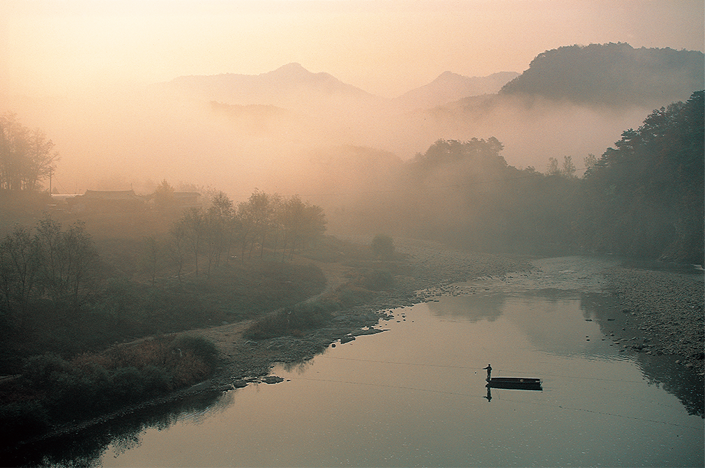
Auraji in Jeongseon is the meeting place of two streams, from where the Namhan [South Han] River originates. The birthplace of “Jeongseon Arirang,” one of Korea’s most-renowned folk songs, this area has long been a famous stop on the waterway where timber from deep in the mountains of Gangwon Province was transported to the capital.
People have long been drawn to Gangwon Province because of its mountains, rivers and seashore. In summer, it’s the sea that is most attractive and in winter, there’s the pristine snow piling up on the mountain tops. In autumn, it is here that the leaves start to change color, the fascinating wave of autumn foliage gradually moving south and spreading over the whole country.
Gangwon Province is located on the eastern side of the Korean peninsula, which is divided along the Baekdu Daegan [“Great White Head Ridge”], the long chain of mountains that forms the backbone of the country. To get there from Seoul you have to cross over the steep mountain passes Daegwallyeong, or Jinburyeong or Misiryeong further to the north. Otherwise, there is a train that goes round the south, past Taebaek and Jeongdongjin and onto Gangneung on the east coast. Or, starting even further south, you can drive along the east coast on national road No. 7, passing by Samcheok, Donghae and Gangneung to reach Goseong, right below the DMZ.
The province is divided into the Yeongdong [“East of the Passes”] and Yeongseo [“West of the Passes”] regions by the Taebaek Mountain Range, which forms one of the main branches of the Baekdu Daegan. The places mentioned above are found in the Yeongdong region. The Yeongseo region is bigger; it includes the cities Chuncheon, Hwacheon and Yanggu. If Yeongdong is a land of mountains and sea, Yeongseo is a land of mountains and rivers. So, within the one province the environment is very different on the eastern and western sides of the mountain range that runs through it.
The Backbone of the Korean Peninsula
The heart of all Korean mountains is the Taebaek Mountain Range. This mountain system encompasses a large number of high mountains. There is aof mountains over 1,500 meters high, including Mt. Seorak, Mt. Odae, Mt. Gariwang, a venue of the 2018 PyeongChang Winter Olympics, and of course, Mt. Taebaek, regarded as sacred since ancient times.
In comparison, Daegwallyeong is just a little hill. But the path over it is the major road through the Taebaek Mountain Range, connecting the eastern and western regions of the province, so the pass is entrenched in the minds of many Koreans as the paramount mountain pass. In the olden days when building a road over the mountains was not easy, the first path connecting the two regions was on Daegwallyeong, rising 832 meters high between Gangneung and Pyeongchang. Therefore, it was a path as well as a gate.
There are no villages along the Baekdu Daegan because the mountains are too rugged. While the area around Daegwallyeong is certainly mountainous, it comprises a wide highlands area. From early summer to autumn, it is carpeted in green vegetables grown at high altitudes. I first went up the pass when I was 17. As I looked at the vast fields of cabbages and radishes, I thought of the Kaema Plateau in North Korea, a place I had never been to and had never even seen in a photograph. Probably it is the fault of the word gowon, meaning “plateau,” in the name. Then I began to understand why adults in those days referred to Daegwallyeong as bisan biya, meaning land that is “neither mountains nor plains.”
It saddens me to think of Mt. Kumgang, located in the northern part of the Baekdu Daegan and hence in North Korea today. I’ve heard that my late grandfather spent every summer at Oncheon-ri, the “spa village” at the foot of the mountain. Only once did I visit the mountain that I had always heard about, as if in a legend. It was back in 2000 when we departed for the mountain beyond the DMZ in a cruise ship from the Donghae port along the east coast.
Temples Nestled Deep in the Mountains
After the nation was divided into North and South Korea by the DMZ, Mt. Seorak became the most famous mountain in the south. Ulsan Rock is no doubt magnificent but it is the ambience of the mountain covered in autumn leaves that makes you think, “Ah, so this is where the fire of autumn is lit.”
In the deep mountains, Buddhist temples were inevitably built. Gangneung is known for its Confucian cultural remains and there are no big temples in this coastal city, but Sinheung Temple and Baekdam Temple, where the famous monk Manhae stayed for many years and drew up a plan to reform Korean Buddhism, are found in the deepest recesses of Mt. Seorak, as are Woljeong Temple and Sangwon Temple on Mt. Odae. In the courtyard of Woljeong Temple is an octagonal stone pagoda from the Goryeo Dynasty and facing it is a stone seated bodhisattva in prayer, both of which survived the ravages of the Korean War when all wooden structures in the temple were destroyed by fire. Sangwon Temple is home to a number of precious cultural treasures, such as Korea’s oldest bronze bell and a wooden sculpture of Manjusri, the bodhisattva of supreme wisdom, as a young boy.
The seated figure of Manjusri is wrapped in legend. King Sejo of the Joseon Dynasty suffered a terrible skin disease and traveled to all famous mineral springs around the country in search of a cure. While he was bathing in the stream below Sangwon Temple, Manjusri appeared to scrub his back and heal him. So the legend goes, and the story is painted on a mural at the temple. There is another story that says the image of Manjusri was originally enshrined at the nearby Munsu Temple by King Sejo’s daughter, Princess Euisuk, to pray for a son but was at some point moved to Sangwon Temple.
The main peak of the Taebaek Mountain Range is naturally Mt. Taebaek, standing 1,567 meters high and being revered since ancient times as one of the three sacred mountains of Korea. This too is a place of legend.
The boy king Danjong, ousted from the throne by his uncle, King Sejo, met his death in the mountains of Yeongwol and came to Mt. Taebaek riding on a white horse to become a mountain god. Another historically significant place in the area is the Mt. Taebaek Archive where a copy of the “Annals of the Joseon Dynasty” (Joseon wangjo sillok) was kept from 1606 to 1910.
Every summer, a rafting festival is held in Auraji, and on the wooden rafts the traditional folk song “Arirang” is performed. Born and set in Auraji, “Arirang” resonates with the joys and sorrows of life, the doleful strains of the song flowing down with the water past Chungju until the stream reaches Yangpyeong in Gyeonggi Province.
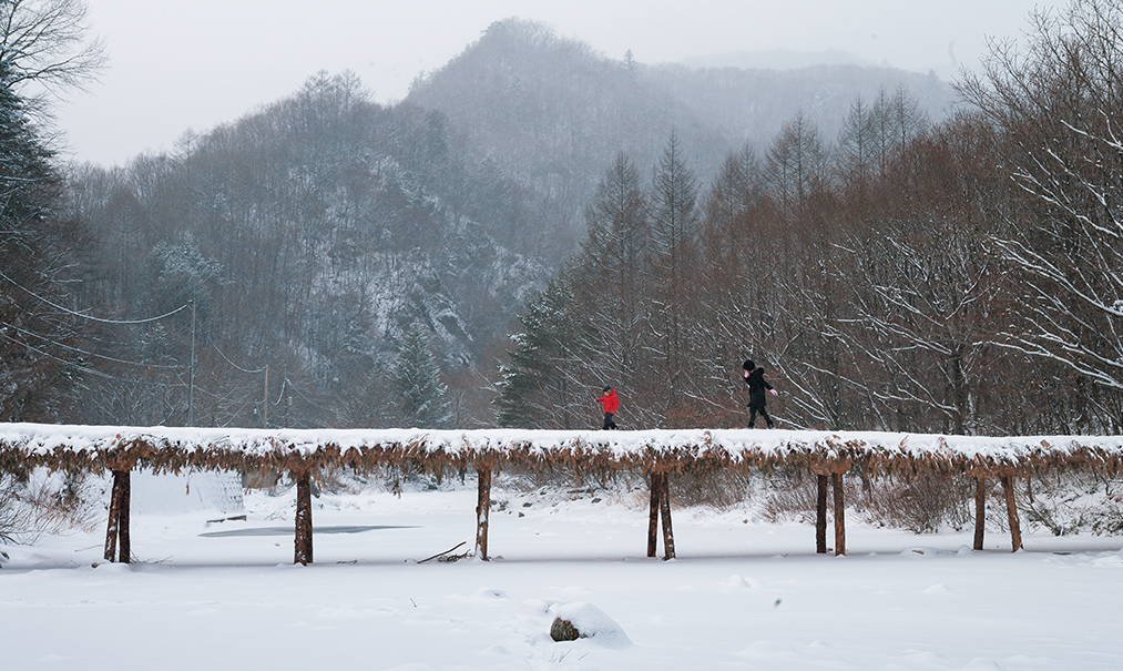
In the deep ravines of Gangwon Province, various kinds of bridges were laid in places where a crossing was necessary. The brushwood bridge (seopdari ) over the Odae Stream on Mt. Odae is one of them.
The Blessing and Gift of Nature
The Taebaek Mountain Range slopes steeply on the eastern side where it runs down to meet the sea. The more gentle slopes on the western side cradle the drainage basin of the Han and Nakdong rivers. In Samsu-dong in the city of Taebaek is a mountain named Samsuryeong, literally the “three waters pass.” As this suggests, Samsu-dong is the watershed for three rivers: the Han River, which flows into the West Sea; the Nakdong River, which flows into the South Sea; and the Osip Stream, which flows into the East Sea. According to a funny old tale, a drop of rain that fell on top of this mountain splashed and separated into three droplets — one flowed eastward, one westward and one southward.
Samsu-dong is also home to Hwangji, the lake that is the source of the Nakdong River, and Geomnyongso, the spring that is the source of the Han River. The main stream of the Han River, called the “lifeline” of the Korean people, runs 514 kilometers, starting from Geomnyongso and meeting with other streams in many valleys to flow into Jeongseon. There it joins Songcheon, a stream that begins at Mt. Hwangbyeong. The spot where these two streams meet is Auraji, whose name means “where two waterways join.” And together, these waterways adorn the landscape. Jeongseon, though mountainous, has fertile land and clean waters, and thanks to the splendid environment, people came here to enjoy the scenery and revel in poetry, music and art. Auraji was also widely known because rafts gathered here to transport wood, cut in the deep mountains across the province, down the Namhan River to Mapo on the southern periphery of the capital, Hanyang (today’s Seoul).
Every summer, a rafting festival is held in Auraji, and on the wooden rafts the traditional folk song “Arirang” is performed. Born and set in Auraji, “Arirang” resonates with the joys and sorrows of life, the doleful strains of the song flowing down with the water past Chungju until the stream reaches Yangpyeong in Gyeonggi Province. There it meets the Bukhan River, originating in Mt. Kumgang, which flows southwestward through Inje, Yanggu and Chuncheon before reaching this spot. Hence its name Dumulmeori, meaning the “heads of two waterways.”
Where the Namhan River joins the Bukhan River, the two form a truly big river. Rivers are the blessing of nature. This is true not only along the upper reaches; those living downstream are also blessed. In Seoul and Gyeonggi Province, 15 million people rely on the downstream of the Han River, while the number of those living upstream is only 800,000. There, none of the water is used for industrial purposes; it is all put to household or agricultural uses. So it is truly clean water that flows downstream, a blissful gift to the city dwellers.
Sunrise Watched from the DMZ
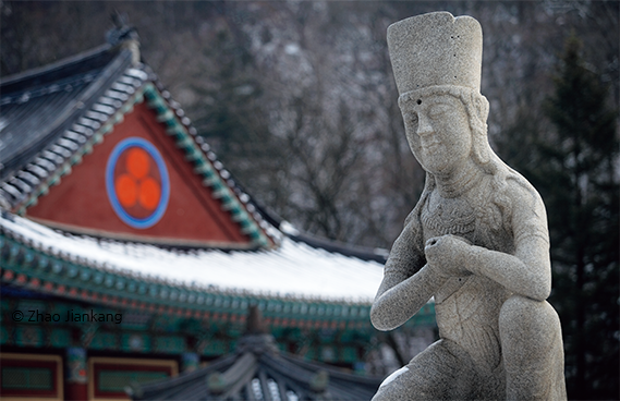
A stone seated bodhisattva graces the main courtyard of Woljeong Temple on Mt. Odae. This is a replica of the original sculpture dated to the 11th century, which is housed in the temple museum.
To most Koreans, “the sea” generally means the blue waters of the East Sea. That is why large numbers of tourists head for Gyeongpo Beach in Gangneung all year round. Not far from Gyeongpo is Jeongdongjin, a renowned spot where people flock every weekend to watch the sun rise over the East Sea. Jeongdongjin Station used to be a little stop, but as the sunrise crowds caught onto the notion that Jeongdonjin is the place closest to the “due east” of Seoul, it has become a big, busy station with 26 trains stopping by daily. The sunrise over the East Sea is a magnificent sight from any part of the coast. Watched from the barbed wire fences of the DMZ at the northernmost part of Gangwon Province, it is as spectacular as it is heartbreaking.
As entrancing as the sunrise over the East Sea is the night view of the sea teeming with fishing boats. The phrase “a city that never sleeps” commonly refers to a city with brightly lit streets at night, but if anything dazzles more brilliantly than such city streets, it’s the hundreds of squid fishing boats out on the sea at night, with their decks covered in light bulbs. It’s a fantastic sight, even from the top of Daegwallyeong far away. Seen close to the water, it is truly spectacular.
As beautiful and lofty as the lights is the hard work that continues on the boats through the night. I remember that during my junior and high school years in Gangneung, the kids who lived in the mining areas always paid their school fees early, no matter what season it was. On the contrary, kids from farming families paid when they could in accordance with their means, while kids from the seaside paid their accumulated fees all at once when the squid were abundant.
Up the coast from Gangneung is Yangyang County. Though not exactly a fishing district on the whole, it is home to Namdaecheon, the “Great South Stream” to which the salmon return every autumn. Upstream, salmon fry that have grown to finger size head off for the East Sea and begin their long, arduous journey to the distant ocean. Then, a few years later, when they have grown to the hefty size of an adult person’s arm, they swim from the North Pacific, through the Bering Sea and the Okhotsk Sea, and back to Namdaecheon in Yangyang where they were born and spent their early days.
A little further north of Yangyang is Sokcho, the fishing base of the east coast. In the past, when the tide came in, the harbor was crowded with fishing boats out to catch Alaska pollack. But with climate change and the rise in water temperature, cold water fish such as pollack have all but disappeared. Nonetheless, Sokcho continues unabated to serve as the hub of the east coast fishing industry. Further north of Sokcho, the wharves of Geojin, Daejin and Ayajin in Goseong County are abuzz with fishing boats according to season.
And even further up the coast, on the road to Mt. Kumgang, the nation’s territory is abruptly cut in half. Civilians can only go as far as the Unification Observatory in Goseong. Although almost forgotten now, up until national liberation in 1945, a train used to run northward along the east coast from Yangyang to Wonsan, via Mt. Kumgang. But when Korea was divided into South and North along the 38th parallel, the tracks were pulled up. In my mind, I imagine the day a railway track leading to Mt. Kumgang is laid again. From the Unification Observatory the coast beyond the border comes achingly into view.
Lee Soon-wonNovelist
Ahn Hong-beomPhotographer