From its fi rst capital Wiryeseong, later known as Hanseong, Baekje twice relocated the capitalsouthward. During the Hanseong period (18 B.c.–A.D. 475), before the capital was moved toungjin (present-day Gongju), the Baekje people built fortresses to protect their capital along thehills of the Han River basin. they formed settlements in the adjacent areas and produced crops.today, the Gangdong and Songpa districts in southeastern Seoul harbor their remains amid rowsof ultramodern buildings and high-rise apartment complexes.
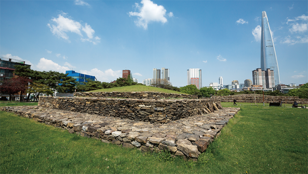
Tomb No. 3 in the Baekje tomb complex in Seokchon-dong,southeastern Seoul, is believed to be the burial place of KingGeunchogo, who significantly expanded Baekje’s territory andpower. Similar in style to Goguryeo tombs, it indicates the closeties between the ruling elite of the two ancient kingdoms.
Out of South Korea’s total population of approximately 50 million, around 20 million live in thenation’s capital, Seoul, and the surrounding metropolitan area. Seoul is a city with a rich history,the cradle of diverse cultures spread over some 2,000 years from the Baekje period to the 21stcentury. Regrettably, the city has not been able to fully express the depth and breadth of its heritage.
Much of the country’s cultural heritage was destroyed during the Khitan and Mongol invasions ofGoryeo (918–1392), and the Japanese and Qing invasions of Joseon (1392–1910). In the 20th century, thecountry was ravaged yet again during Japan’s colonial occupation and the Korean War. A significant portionof the cultural remains that did manage to survive these upheavals were lost later when industrialand economic development swept the country.
One may say that the remnants of Seoul’s historical and cultural heritage exist as “dots.” Only whenthe dots are connected and become lines, the lines become planes, and the planes are reconstructedinto three-dimensional structures, will we be able to fully appreciate the city’s historical and culturalvalue.
A State Founded in the Han River Basin
In the East Asian tradition, the life of all living beings is perceived in terms of organic relationshipsbetween heaven, earth, and humans. The land on which people live is largely made up of mountainsand rivers, which are forever interconnected, sharing both mutually inverse and beneficial relationships.Water that arises from where two mountain ranges meet flows along the valleys and gorges surroundedby the mountains; from remote ancient times, people settled near these water sources.
During the Three Kingdoms period from the first century B.C. to the seventh century, when Baekje,Silla, and Goguryeo competed and cooperated with one another as circumstances demanded, they frequentlywaged wars to seize the Han River basin at the heart of the Korean peninsula.
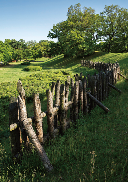
Wooden palisades are restored along the northern edge ofthe Mongchon Earthen Fortress.
Prior to theseterritorial contests, Baekje was the first to occupy the region. There are various views as to the foundingof Baekje, but it is generally believed to have been founded by the brothers Onjo and Biryu, wholeft the kingdom of Buyeo in today’s northeastern China and came southwith a small group of vassals. They were the sons of King Dongmyeong, orJumong, founder of Goguryeo; the younger brother, Onjo, settled in the HanRiver basin, while his older brother, Biryu, settled in Michuhol (presentdayIncheon). Onjo initially named his country Sipje after the ten (sip) vassalswho had followed him. When his brother died, Onjo welcomed Biryu’speople into his land and renamed his country Baekje, manifesting his nowmuch larger contingent of vassals, baek meaning one hundred.
Advancing further south, they took 40 kilometers of land ceded by Mokji,leader of the 54 states comprising the Mahan confederacy that ruled thearea of today’s Gyeonggi, Chungcheong and Jeolla provinces. Eventually,they annexed Mokji, becoming the leading power in the confederacy andconsolidating the foundations for Baekje. In its early years, Baekje wasdivided into five administrative regions; the king only ruled directly over thecapital while the other areas were governed indirectly through local administrativeheads. But it soon established its ruling system as an ancient kingdomand built fortifications to strengthen its defenses and accommodatethe increasing population.
Thus were built two earthen fortresses, Pungnap and Mongchon, theformer on flat land with residents living inside its walls and the latter on anadjacent hilly area to be used in times of emergency. The Pungnap EarthenFortress was located north of the royal palace, hence called the northernfortress, while the Mongchon Earthen Fortress was situated south, hencethe southern fortress. This dual fortress system is mirrored in Goguryeo’s1 Gungnae Fortress and Hwando Mountain Fortress in northeastern China.
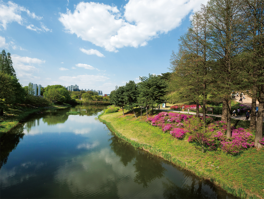
The moat surrounding the Mongchon Earthen Fortress hasbeen turned into a pond.
The royal palace is believed to have been located inside the fortress walls. According to the “History ofthe Three Kingdoms” (Samguk sagi), the palace had many buildings that were “modest but not shabby,magnificent but not extravagant.”
History Gleaned from the Ruins
The Pungnap Earthen Fortress was built on flat land along the Han River. The fortress walls measure3,470 meters in circumference, 6–13.3 meters in height, and 30–70 meters in width, and were surroundedby a moat to deter enemy intrusions. The fortress is of a long oval shape stretching north and south;the east wall stretches over approximately 1,500 meters, the south wall 200 meters, and the north wall300 meters. The west wall was destroyed by heavy floods in 1925, but has since been restored. The wallsare disconnected in four places, where the city gates are assumed to have been situated.
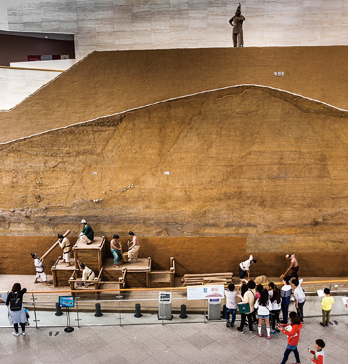
The cross section of a replica ofthe wall of the Pungnap EarthenFortress is on display in the lobbyof the Seoul Baekje Museum. Itshows the s of earth piled upto build the fortification.
The royal palace is believed to have been located inside the fortress walls. According to the “Historyof the Three Kingdoms” (Samguk sagi), the palace had many buildings that were “modest but not shabby,magnificent but not extravagant.”
Excavations have revealed a three-tier ditch around the village facilities and fortress walls, with variousartifacts found relatively intact. The ruins of roads and water holes indicate that the palace hadmany state facilities within its walls.
The Mongchon Earthen Fortress, located some 700 meters southeast of the Pungnap Earthen Fortress,has a unique structure with outer and inner walls built on hilly land descending from a highmountain. The walls were made by piling up mud, and steep slopes were cut when necessary.
Wooden palisades were erected along the northern edge of the fortress, with a moat outside providingadditional protection, which has now been turned into a pond. The fortress walls total 2,285 metersin length when measured from the highest point, and overall, the height is around 30 meters. The northeasternsection of the outer wall was built in a straight line measuring approximately 270 meters.
Traces of wooden palisades on the northern slope and the highest point of the outer wall, a steeperincline d on the east side, and a moat surrounding the outer wall all suggest that the fortressserved as a base to guard against invasions from the north.
Fortress for a Dual Purpose
Vestiges of a storage pit and military facilities, such asa stamped dirt mound where a watchtower presumablystood, support the assumption that the fortress functionedas a bastion against enemy attacks and a shelter for peopleevacuated in times of emergency.
Recent excavations and surveys brought to light an18.6-meter-wide, two-lane road. It is the largest amongthe roads dating from the Baekje period and the oldesttwo-lane road discovered in the country to date. Passingthrough the north gate of the Mongchon Earthen Fortress,it was presumably the main road connecting the two fortresses.After Baekje relocated its capital southward andthis area became Goguryeo territory, the road was repairedand extended three times. Paved with a mixture of stones,weathered soil, and clay, the road is so hard that no wagonwheel impressions are found on it.
Among other important artifacts discovered here arefragments of a Baekje pottery jar with a short neck andstraight mouth, inscribed with the Chinese character 官(gwan), meaning a government office. This is the first pieceof earthenware with such an inscription unearthed from theruins of the Baekje period, which reaffirms that this fortresswas not just a defensive structure but a fortified city.
Tombs of the Baekje ruling class are scattered aroundthe present-day Seokchon-dong, Garak-dong, and Bangi-dong areas,south of the two fortresses.
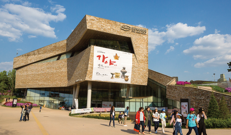
The Seoul Baekje Museum,located inside the Seoul OlympicPark, offers diverse exhibitionshighlighting the prehistoric era beforethe founders of Baekje settledin the Han River basin, as wellas their two neighbors Goguryeoand Silla, who later occupied theregion.
TIME TRAVEL TO BAEKJE ON FOOT
Surrounding Lotte World, a major recreation and shopping complexin Jamsil, southeastern Seoul, is Seokchon Lake. It was originallypart of the Han River, but was turned into a lake when thedirection of the river’s flow was altered in the 1970s for protectionagainst floods. It is divided into the east and west lake, and standingon the slope of the west lake is the Samjeondo Monument markingthe surrender of Joseon to Qing after the second Manchu invasion(1636–1637). Starting from here, walk halfway around the westlake, then down the road running through the densely populatedresidential area in the south until you reach the ancient tombsof Baekje in Bangi-dong. After looking around the stone moundtombs and other tombs dating back to the Hanseong period (18B.C.–A.D. 475) of Baekje, head to the Seoul Olympic Park.
The Seoul Olympic Park, built on land that was originally the siteof the Mongchon Earthen Fortress, contains the main indoor stadiumsthat were built for the 1988 Summer Olympics. In the frontgarden of the Seoul Baekje Museum, also located inside the park,you can appreciate sculptures by world famous artists. Next, youcan enjoy a leisurely walk along the gentle slopes of the ancientramparts and then perhaps make a stop at the Mongchon Museumof History, a fun place to learn about the history of the Baekje Kingdom.
If you exit the park through North Gate 1, walk past the GangdongDistrict Office, and cross the main road, you will find YoungpaGirls’ High School. Walk along the school wall toward the residentialarea, and the gentle curves of another fortification, the imposingPungnap Earthen Fortress, will come into view.
This walking tour of the historic sites of Baekje from the firstfive centuries of its rule will take a good full day. It can be strenuousbut walking is the best way to truly appreciate this area, where themodern and ancient intersect.
The third volume of “Illustrated Records ofHistoric Sites in Korea” (Joseon gojeok dobo), published in 1916 duringthe Japanese colonial era, says that 66 stone mound tombs and 23earthen mound tombs existed in the area. Currently, only seven largestone mound tombs as well as 30 or so wooden and pottery coffintombs remain. The fact that stone mound tombs, which are associatedwith Goguryeo, have been found in this area indicates that the foundersof Baekje had close ties to their northern neighbors. Small wooden coffintombs belonging to commoners or officials from different historicalperiods have also been found in the area.
Between the third and fifth centuries, tombs belonging to people ofvarious ranks were constructed in today’s Seokchon-dong area, forminga tomb complex. Tomb No. 3, the largest among them, is a pyramidshapedstone mound tomb 4.5 meters high, the longest side measuring45.5 meters, and the shortest 43.7 meters. Currently, only three stonetiers remain of the tomb, which is presumed to have been built betweenthe mid-third and fourth centuries. King Geunchogo (r. 346–375), the13th ruler of Baekje who significantly expanded its territory and power,is believed to be buried here.
After the capital was relocated to present-day Gongju in 475, thetombs of the ruling class changed in style from square stone mounds tostone burial chambers covered with earthen mounds. The tomb of KingMuryeong (r. 501–523), discovered in 1971, was the first stone chambertomb with a horizontal entranceway, which became the prevalent type ofroyal tomb in all three kingdoms from around this time.
The Mongchon Earthen Fortress, excavated and surveyed six times in the1980s, is now parkland for the citizens of Seoul.
Searching for the Remaining Puzzle Pieces
With development of the Jamsil district in the 1970s, the “time capsule”of Baekje, as this area is known, changed rapidly amid conflictbetween urban development and heritage preservation. In the 1980s, itwas chosen as the site of the Seoul Olympic Stadium, and various sportsarenas and facilities were built throughout the area. Thus the 1988Summer Olympics were held where the ancient capital of Baekje oncestood, bearing witness to history and culture spanning 2,000 years.
The city that was constructed over five centuries with the wisdomand labor of the Baekje people has disappeared; in its place are rowsof high-rise apartment buildings that are among the most expensive inSeoul. The urban development and renewal projects, such as the constructionof apartment complexes, roads, and Olympic venues, did yieldsome positive results in that they led to the unexpected discovery ofancient relics buried underground. Efforts are ongoing to restore theancient city and the lives of its residents, connecting the dots into lines,and lines into planes, and planes into three-dimensional structures.
Choi YeonGeographer; Principal ofthe Seoul School, Center forHumanities Studies
Ahn Hong-beomPhotographer
 한국국제교류재단